| Luquillo In The Path |
|
| Luquillo In The Path |
|
|
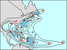
Tropical storm frequency per unit area (16,500 square miles) during August from counts of the storm track for the years 1877 to 1956. Ballenzweig (1959). The outer most contour is 4 storms in the period. Contour interval is 4 storms. Local maxima are darker blue and minima are uncolored. The red arrows indicate the axis of maximum values and the most common tropical storm tracks. The large blue area to the east of Puerto Rico had more than 20 but less than 24 storms during the period of record. A latitude x longitude "square" 2.5 degrees on a side would contain about 16,500 square miles
Nowhere in the North American sector are tropical storms more common than immediately to the east of Puerto Rico. Hurricane Hugo made landfall on Puerto Rico and opened the flood gates of new scientific inquiry for the Luquillo LTER program. However many hurricanes and tropical storms have come close but skirted by just to the north or to the south of Puerto Rico. The illustration above shows that the mean track of tropical storms (including hurricanes) divides just to the east of Puerto Rico and defines two characteristic tracks. One stays to the south of Cuba and Jamaica and crosses Yucatan and then the Mississippi Delta. the second track skirts the north coast of Puerto Rico, stays to the north of Cuba and turns north to nip Cape Hatteras, North Carolina before crossing the northern latitudes of the north Atlantic.
The map shows the tendency of tropical storms to "avoid" land. Avoid in the sense that the fuel (latent energy) for tropical storms is from the evaporation of the oceans. Also, the storms avoid land because passing over land with its rough, vegetated surface the momentum of the winds are reduced. This surface control contribution to the storm path is perhaps most evident in the low latitudes where steering by winds aloft is minimum. In the middle and high latitudes it is not the nature of the surface so much as the specific geography of the jet stream aloft. The minimum in tropical storm frequency (<4 / 16,500 square miles) is clear over Cuba. Puerto Rico gets 4 to 5 times as many tropical storms as Cuba.
In a paper in Climate Change O'Brien, Hayden and Shugart used a ZELIG model to examine the impact of hurricane frequency and magnitude on tropical forest structure at the Luquillo LTER site. This work extended the approach first presented by Doyle (1981). Our ZELIG model was run under 115 different combinations of tropical storm frequency and magnitude. The model produced estimates of big stems per hectare, all stems per hectare, total basal area, total biomass, leaf area index, two classes (guilds) of pioneer and three classes (guilds) of mature forest species. PCA was used on the model output statistics and tropical storm frequency and magnitudes (the variables) for the 115 model runs (the cases). The first component was termed the late successional factor as mature species, high total biomass, basal area and LAI were strongly weighted and was related to low tropical storm frequency and modestly lower tropical storm intensity. The second component was termed the early successional factor as pioneering species were positively loaded and mature species negatively loaded. Basal area, biomass and LAI were negatively correlated and number of stems positively correlated. This second component also was loaded on tropical storm intensity but unrelated to storm frequency. That is with strong hurricanes mature tropical forest development is suppressed
Ballenzweig, E.M. (1959). A practical equal-area grid. J. of Geophysical Research 64(6):647-651.
O'Brien, S. T., B. P. Hayden, and H .H. Shugart (1992). Global climatic change, hurricanes, and a tropical forest.


