| Seasonal and Annual Changes in the Cedar Creek Storm Track |
|
| Seasonal and Annual Changes in the Cedar Creek Storm Track |
|
|
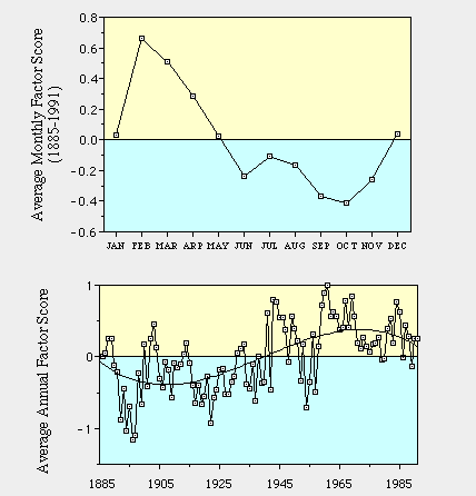
The illustration is color coded to match the illustration of the track itself which was shown in blue. Blue on this illustration indicates that the track was occupied more than the average occupancy and yellow less than average use of this track. The magnitudes of the monthly or annual scores indicates how much more or less than average that the track was used.
The illustration above tells us that this track is used most in summer and fall and least in winter and what passes for spring in Minnesota. During the summer and fall the jet stream is far to the north and provides the south and eastward steering for these storms. In late fall and through the winter the jet and often used storm tracks are further south.
There is as well an interesting long-term history to the frequency of storm along this track. The track was occupied more frequently in the early years of record and maximum in the first decade of the 20th century. This track was least frequently used by storms in the 1960s. Since then the storms along this track have become more frequent.
To get some idea of the magnitude of this climate change consider the range of loading indicated for the seasonal cycle (+.6 to -.4). The long-term climate change amplitude for the smoothed curve is (+.3 to -.3). The long-term variation is of the same order of changes as the seasonal cycle. If this were true of temperature we probably would not be debating the reality of global warming. In addition the extreme positive and negative years show a change larger than the seasonal cycle.